
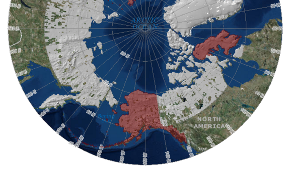
The first-ever publicly available, high-resolution, satellite-based elevation data map of Alaska has been released by The National Geospatial-Intelligence Agency (NGA) and The National Science Foundation (NSF) partnered with the University of Minnesota. Maps of the entire Arctic will be available by 2017. These Maps will provide users with new insight and information on conditions such as natural earth features, shipping and hydrography, sea ice extents, and glacial changes.
These computer generated 3D elevation models (also known as Digital Elevation Models or DEM’s) are the first to come from the ArcticDEM project. ArcticDEM is a NGA-NSF public-private initiative that was created after an executive order in January of 2015 called for improved decision making and enhanced coordination in the Arctic region.
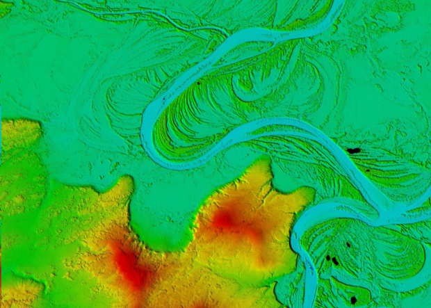
Esri, a GIS provider, hosts the NGA Arctic Support site which features web maps, map viewers, DEM exploratory tools, nautical charts, sailing directions and infographics, and a downloadable Pan-Arctic map with mission-specific data layers. The new maps have a resolution of five meters or less; compared to current Arctic elevation models, which have a resolution of one kilometer. This project is the first of its kind: The Arctic is now being displayed in a high-resolution, high-quality, and openly distributed set of DEMS through the use of optical stereo imagery and high performance computing. .
This technology changes polar mapping by allowing for thorough coverage of the Arctic region. The traditional way of creating a DEM involved flying an airplane over a region and taking pictures or shooting lasers from the air. With this method, much of the Arctic was previously restricted due to inhospitable conditions and remote locations. Satellites on the other hand, continuously orbit the earth and are providing new image data that is easier to obtain and more cost-effective. The image data is based on 2-meter resolution images captured by Colorado-based DigitalGlobe satellites. Each day the DigitalGlobe satellites collect the area equivalent of California in the Arctic. The data from these satellites is fed into The University of Illinois’ Blue Waters supercomputer.
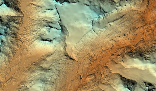
According to the University of Illinois, the production of these comprehensive and fine-scale DEMs is transforming the Arctic research community. They are providing scientists with time-stamped observations and will provide information about “ice and volcano interactions, process geomorphology, tectonic geomorphology, plate boundary interactions, fault expressions, fault evolution, glacial geomorphology, and solid earth geodynamics derived from bending lake shorelines,” The detail of the DEMs allow for a new level of analysis. Scientists can now see surface water flows on glaciers down to the level of individual lakes and streams.
The DEMs and datasets will be used for:
- Monitoring sea level changes, coastal erosion and the volume of glaciers
- Monitoring storm surges from rising sea levels
- Employing emergency management strategies
- Ecosystem management
- Protecting the health of Arctic communities
- Supporting informed land management
- Increasing sustainable development
- Creating safe recreation
- Aviation and transportation
- National defense industries
See Also: Ways to use elevation data
By comparing images from different time periods, these high-resolution maps will help scientists understand and measure the rapid and ongoing changes that the Arctic landscape faces as a result of climate change and human use. When the project is complete, ArcticDEM will encompass all land area north of 60 degrees north. Coverage will include Greenland, Alaska, and the Kamchatka Peninsula of the Russian Federation. This initiative is expected to create a comprehensive elevation model of the Arctic within two years.
