Mapping the Arctic: 3D High Resolution Technology

The first-ever publicly available, high-resolution, satellite-based elevation data map of Alaska has been released by The National Geospatial-Intelligence Agency (NGA) and The National Science Foundation (NSF) partnered with the University of Minnesota. Maps of the entire Arctic will be available by 2017. These Maps will provide users with new insight and information on conditions such as natural earth features, shipping and hydrography, sea ice extents, and glacial changes.

Screen shot 2017-02-21 at 4.31.05 PM.png

These computer generated 3D elevation models (also known as Digital Elevation Models or DEM’s) are the first to come from the ArcticDEM project. ArcticDEM is a NGA-NSF public-private initiative that was created after an executive order in January of 2015 called for improved decision making and enhanced coordination in the Arctic region.

Esri, a GIS provider, hosts the NGA Arctic Support site which features web maps, map viewers, DEM exploratory tools, nautical charts, sailing directions and infographics, and a downloadable Pan-Arctic map with mission-specific data layers. The new maps have a resolution of five meters or less; compared to current Arctic elevation models, which have a resolution of one kilometer. This project is the first of its kind: The Arctic is now being displayed in a high-resolution, high-quality, and openly distributed set of DEMS through the use of optical stereo imagery and high performance computing. .

This technology changes polar mapping by allowing for thorough coverage of the Arctic region. The traditional way of creating a DEM involved flying an airplane over a region and taking pictures or shooting lasers from the air. With this method, much of the Arctic was previously restricted due to inhospitable conditions and remote locations. Satellites on the other hand, continuously orbit the earth and are providing new image data that is easier to obtain and more cost-effective. The image data is based on 2-meter resolution images captured by Colorado-based DigitalGlobe satellites. Each day the DigitalGlobe satellites collect the area equivalent of California in the Arctic. The data from these satellites is fed into The University of Illinois’ Blue Waters supercomputer.

screen-shot-2017-02-21-at-4-31-59-pm
Wolverine Glacier:a valley glacier in the coastal mountains of south-central Alaska’s Kenai Peninsula. These images help with climate change monitoring and allow users to observe and document changes as they occur.

According to the University of Illinois, the production of these comprehensive and fine-scale DEMs is transforming the Arctic research community. They are providing scientists with time-stamped observations and will provide information about “ice and volcano interactions, process geomorphology, tectonic geomorphology, plate boundary interactions, fault expressions, fault evolution, glacial geomorphology, and solid earth geodynamics derived from bending lake shorelines,” The detail of the DEMs allow for a new level of analysis. Scientists can now see surface water flows on glaciers down to the level of individual lakes and streams.

Screen shot 2017-02-21 at 4.42.26 PM.png
The Winding Koykuk River in Western Alaska: a 425 mile-long tributary of the Yukon River. DEM models show the boreal forest vegetation patterns surrounding the region in greater detail than ever before.

The DEMs and datasets will be used for:

  • Monitoring sea level changes, coastal erosion and the volume of glaciers
  • Monitoring storm surges from rising sea levels
  • Employing emergency management strategies
  • Ecosystem management
  • Protecting the health of Arctic communities
  • Supporting informed land management
  • Increasing sustainable development
  • Creating safe recreation
  • Aviation and transportation
  • National defense industries

See Also: Ways to use elevation data

By comparing images from different time periods, these high-resolution maps will help scientists understand and measure the rapid and ongoing changes that the Arctic landscape faces as a result of climate change and human use. When the project is complete, ArcticDEM will encompass all land area north of 60 degrees north. Coverage will include Greenland, Alaska, and the Kamchatka Peninsula of the Russian Federation. This initiative is expected to create a comprehensive elevation model of the Arctic within two years.


The Future of Hydroelectric Power

Hydroelectric Power is a renewable energy source that is produced by capturing the kinetic energy of flowing or falling water. Although this technique has been practiced since ancient times, it is a technology that still has a great deal of potential for growth.  

Screen shot 2017-02-21 at 4.08.30 PM.png

Hydropower: A Leader in Renewables

Hydropower is the largest source of renewable energy in the world. Globally, this technology represents around 16% of total electricity consumed and dominates 85% of renewable electricity. In the United states, Hydroelectric energy accounts for around 10% of the total electricity generated, allowing the nation to avoid 200 million metric tons of carbon emissions each year.

According to the US Department of Energy, hydropower could grow by 50,000 megawatts by 2050. This would lead to a reduction of 5.6 billion metric tons of greenhouse gas emissions and a savings of $209 billion dollars by avoiding the damages of heat-trapping emissions. With new technology hydropower can become even more efficient, and have greater production capacities.

Hydroelectric Technologies

The term “hydropower” covers multiple technologies ranging from large to small and old to new: https://www.youtube.com/watch?v=tpigNNTQix8

Reservoir Hydropower Plant: This type of impoundment facility is most common, representing the majority of U.S. hydropower generation. Impoundment facilities, typically larger in size, require a river dam to store water in a reservoir behind a generating facility. The water released from the reservoir then flows through a turbine, which spins blades producing mechanical energy that is then sent through transmission lines. This technique provides flexibility to generate electricity on demand and as needed, reducing dependence the the variability of inflows.

screen-shot-2017-02-21-at-4-12-21-pm
Reservoir Plant

Pumped Storage Plant: Electricity demand is not “flat” and constant, it fluctuates based on peak hours and usage. PSP’s act like a battery, storing power in the form of water when demands are low and producing maximum power during daily and seasonal peak periods. When electricity supply exceeds demand or can be generated at low cost, these plants take energy from the grid to power generators that pump water from a lower reservoir to a higher reservoir, where the water is then stored. During periods of high electrical demand water is released from the upper reservoir back down to the lower reservoir, thus spinning the turbines and generating electricity. PCP is a net consumer of electricity, but provides for effective electricity storage.

screen-shot-2017-02-21-at-4-13-53-pm
Pumped Storage Plant

Diversion hydropower plant: Diversion plants, also called run-of-river plants, harness energy from the available flow of the river. They do this by channeling portions of a river through a canal or penstock, and may not require the use of a dam. These plants include short-term storage or “pondage” allowing for some hourly or daily flexibility, but this generation profile is mainly driven by natural river flow conditions or releases from any upstream reservoir. In the absence of an upstream hydropower plant, generation depends on precipitation and runoff in addition to having seasonal variations.

Screen shot 2017-02-21 at 4.14.57 PM.png
Diversion Plant

Pros

  • Clean Energy: Hydropower is renewable and clean. The generation process does not produce toxic by-products or pollutants, and water can be used later for irrigation and consumption.
  • Safety: Unlike nuclear energy and fossil fuels, hydropower does not pose a potential health risk to the public. There are no oil spills, or nuclear leaks.
  • Flexibility: The water flow and energy output can be adjusted based on consumption and storage capacity. Many facilities can go from zero to maximum output, making them ideal for meeting sudden changes in electricity demand.  
  • Cost-Effective: According to a recent analysis by Navigant Consulting, Inc. hydropower was the most affordable at $.02/kWh. States that get the majority of their electricity from hydropower (Idaho, Washington, Oregon) have energy bills that are lower than the rest of the country.
  • Durability: Dams can be operational for decades with few investments once required once constructed.
  • Multi-Functional: In addition to electricity production, dams can be used for irrigation, shipping and navigation, flood control, or to create reservoirs for recreation.


Cons

  • Environmental impact: The construction of a dam damages ecosystems,  changes water levels, and floods large areas. Some fish, such as salmon shad and sturgeon, may be prevented from swimming upstream to spawn. Technologies such as fish ladders have been developed to help salmon go up over dams, but the presence of these dams still changes migration patterns and harms fish populations. Hydropower plants can also result in low dissolved oxygen levels, which harms river habitats.
  • Displaced people: The construction of a large dam often requires that entire towns move out of the area. In the construction of the Three Gorges Dam in China, it is estimated than 1.2 million people were displaced.
  • Expensive: building a dam requires a large initial investment
  • Accidents: in the past, dams have breached leading to flooding and casualties


Future Growth

Modernizing: New technology must be employed at existing sites by installing more efficient turbines, enhancing performance, and minimizing environmental externalities so that existing infrastructure can generate more power sustainably

Converting Non-Powered Dams: Out of 80,000 dams across the U.S. only 3% have electricity generating equipment. Converting these facilities will increase America’s renewable energy by 12 GW

Conduit Technology: Retrofitting existing tunnels, canals, pipelines, aqueducts, and other manmade structures that move water with electricity-generating equipment will utilize already available infrastructure into an energy-generating asset.

Micro-Hydroelectric Systems: The next phase of hydropower will focus on smaller units that are less environmentally disruptive and costly, but still useful in supplying electricity to remote areas. According to Idaho Falls-based research lab, about 170,000 megawatts of hydropower remains untapped and unrestricted from development by the federal government. Small or micro-hydroelectric power systems can produce enough electricity for a home, farm, or ranch and should not be overlooked.  At least 100 countries are developing small hydro plants. These smaller so called run-of-the-river facilities does not require the construction of dams which requires high initial investments, blocks water and kills aquatic life.

Marine and Hydrokinetic Technologies: In recent years, a profusion of new technologies have emerged in the market including tapping into the kinetic potential of Ocean waves, tides and river flows. About 71 percent of the Earth’s surface is water-covered, and the oceans hold about 96.5 percent of all Earth’s water. Thousands of megawatts of untapped potential are available from such projects. The predictability of tidal power is attractive for grid management. Unlike many other sources of renewable energy, water is continuously moving and consistent, removing the need for back-up plants powered by fossil fuels.

  • Tidal turbines installed on the seabed at sites with high current velocities are a great starting point. To be successful in these installations, engineers and designers can look marine biology as a means to gain insight into how these turbines can gracefully move underwater.
  • Despite being nearly 80,000 pounds, Humpback whales can swim in tight circles and dive hundreds of feet. In 2004 Scientists at Duke University, West Chester University, and the U.S. Naval Academy discovered that the bumps on their fins, called tubercles, aid in their surprising dexterity. According to asknature.org, “Wind tunnel tests of model humpback flippers with and without leading-edge tubercles have demonstrated the fluid dynamic improvements tubercles make, such as a staggering 32% reduction in drag, 8% improvement in lift, and a 40% increase in angle of attack over smooth flippers.” This biomimetic approach to design could aid in developing underwater turbines that will limit friction and drag, thus harvesting more energy.
Screen shot 2017-02-21 at 4.19.30 PM.png
See more biomimicry at asknature.org


Biomimicry: Using Nature as Design Inspiration

Screen shot 2016-12-04 at 4.54.12 PM.png

“When we look at what is truly sustainable, the only real model that has worked over long periods of time is the natural world.” -Janine Benyus

What has skin like a shark, the iridescence of a butterfly, capillaries like a tree, and the structure of a molecule? The Future of Engineering

In a human-centric world, we often look to other humans for answers to global challenges. What is the most efficient way to use resources? How can we design better systems in which these resources function? Often, without intending to, we create other problems in the process. 

Engineering and Architectural professionals are now seeking innovative ways to create beautiful, sustainable, and resilient design solutions. Those on the leading edge are increasingly looking to Nature as a source for inspiration.

For 3.8 billion years nature has developed intelligent ways to solve problems relative to our own innovative challenges. Animals, plants, and microbes are exceptionally efficient and effective engineers. Out of necessity, organisms have learned how to create systems conducive to life. These organisms live here gracefully, while humans ponder how to solve global warming, pollution and resource scarcity. Modern culture appears to have adopted a mindset of tragedy. Human beings are not facing a resource crisis, but rather a design crisis. Biomimicry is an emerging field, which seeks sustainable solutions to human challenges by emulating nature’s patterns and strategies. What if every inventor started with the question, “How would Nature solve this?”  Using Biomimicry, design can be imbued with inherent intelligence, resulting in radical savings in resource efficiency.

The Biomimetic Approach

Scientist Janine Benyus popularized the term Biomimicry in her 1997 book Biomimicry: Innovation Inspired by Nature, but the concept is not a new one. Leonardo Da Vinci observed birds in flight as an inspiration for his proposed sketches of “flying machines” The Wright Brothers went on to use these documents for the invention of the airplane in 1903. Biomimetics has since become a guideline that has permeated science, medicine and engineering.

biomimicy_01_02_03.jpg

How does Nature Redistribute or Filter Water, Oxygen and Blood?

Biologists have discovered what is referred to as Murray’s Law; All branching structures, whether the lungs or a tree, follow a single mathematical formula. This formula represents the most efficient way to transport resources through vessels. Using these blueprints, engineers and designers can utilize algorithms to distribute or filter water more efficiently through capillary action and transpiration. This technology is now being used to create plumbing, electrical and water filtration systems.

screen-shot-2016-12-01-at-2-31-18-pm

How Does Nature Use Minimal Resources for Maximum Efficiency?

Trees and bones are constantly reforming themselves along lines of stress. This algorithm is now being put into software to make bridges and construction lightweight and durable. This breakthrough is helping to create bionic cars, using limited material for the maximum amount of strength.

bionic_car

These are the Spinneret glands on the abdomen of a spider:

6fb8f2b569bf6d754af5bf02a68cb8a8
Spinneret glands produce a silk that is tougher than any man made fiber, using only the raw materials of dead flies and water.

A Spiders web silk can be as strong as kevlar used in bulletproof vests. Dragline silk fibers change web tension by contracting and relaxing in response to humidity.  Such flexible, adaptable, strong, and low-density materials are highly desirable to material engineers. This material could potentially be used as a model for suspension bridge cables, artificial ligaments, and sensors.

Whale=Wind Turbine:

whale.jpg

Despite being nearly 80,000 pounds, Humpback whales can swim in tight circles and dive hundreds of feet. In 2004 scientists at Duke university, West Chester University, and the U.S. Naval Academy discovered that the bumps on their fins, called tubercles, aid in their surprising dexterity. According to asknature.org, “Wind tunnel tests of model humpback flippers with and without leading-edge tubercles have demonstrated the fluid dynamic improvements tubercles make, such as a staggering 32% reduction in drag, 8% improvement in lift, and a 40% increase in angle of attack over smooth flippers before stalling.” This information is now being applied to wind turbines, airplanes and fans.

Other designs inspired by Nature: adhesive glue from mussels, Bullet train in Japan inspired by Kingfisher beak, fabric that is bacteria resistant like shark skin, and harvesting water from fog like a beetle.

kingfisher.gif

The streamlined Shinkansen train travels more quietly, it now moves 10% faster and uses 15% less electricity.

Biomimicry and the Built Environment

The built environment is the most fertile ground for biomimicry. According to the USGBC, Buildings account for around 39% of CO2 emissions and consume 70% of the electricity load in the U.S. Like nature, humans require resilient, zero-energy, zero-waste regenerative environments that are adaptive, responsive and aware.

Ecosystems purify water, mitigate flooding, create habitats, sequester carbon, adapt to their environments, harvest energy, and recycle waste. By emulating nature’s genius, the built environment can gracefully provide these ecosystem services.

ecosystem-services-diagram.jpg

A Paradigm of Success

The Eden Project, a popular visitor attraction in Cornwall England, has exemplified how and sustainability can successfully integrate into architectural and engineering projects. The Eden project is a charitable enterprise and home to the largest indoor rainforest. The goal of this project was to create a landscape that would educate people about the living world and provide a framework for collaboration towards building a better future.

24-eden-project-united-kingdom-online-architecture-gallery-top-50-most-amazing-designs-in-the-worldhttps://www.youtube.com/watch?v=f8unx8-pZxg

Constructing the Biomes

The site, designed by Grimshaw Architects, was being quarried, and therefore provided a unique challenge: How do you build a large greenhouse on a piece of land that is irregular and continually changing? Examples from biology provided solutions to these challenges. It was soap bubbles that helped to generate a building form that would work regardless of final ground levels. Studying pollen grains, radiolaria, and carbon molecules helped the team devise the most efficient structural solution using hexagons and pentagons.

screen-shot-2016-12-06-at-5-00-37-pm

Due to weight impositions, these hexagon and pentagon panels couldn’t be made of glass. The team used a material called ETFE, a high strength polymer, which could be manufactured in units seven-times the size of glass and still remain stable. In comparison to glass, the weight of these ETFE panels is one percent, yet they are strong enough to withstand the weight of a car, resulting in factor 100 savings. With such large, lightweight panels, the building required less steel; This meant that more sunlight could get in, therefore the building required less heat and electricity. The hexagonal cushions trap air between two layers of ETFE, which acts as a thermal blanket. In addition ETFE resists corrosion and self cleans. ETFE is easily recyclable, meaning at the end of its useful life it becomes technical nutrition for a new product. The result is a highly efficient and sustainable structure that weighs less than the air contained within it.

EDEN Planted Interior HTB 2.jpg

Constructing the Corefib6.jpg

The core of the building is an education center, which tells the story of plants using biomimicry and sustainable construction. It incorporates a canopy roof that provides shade and harvests sunlight. The roof, created from an intricate web of curved timber beams, is based on Fibonacci spirals (a mathematical pattern that is found throughout nature).

the_core_eden.jpg

Water Harvesting

With more than 850,000 visitors each year and around 2 million plants, water usage was an important aspect of the project design. About two thirds of the water needed to operate the Eden project is provided through rainwater harvesting. Water that falls on top of the biomes irrigates the plants inside, fuels the rainforest waterfall, and maintains the high humidity inside.

103da9381a0fc4f1c7f1ad81c7591185_86277547_chinaedenplan.jpgThe Biomimetic approach and the sustainable features implemented in The Eden                   Project serve as a guideline for achieving radical savings in resource efficiency.

The Key to Success

“You Could Look at nature as being like a catalog of products, and all of those have benefited from a 3.8 billion year research and development period. And given that level of investment, it makes sense to use it.” –Michael Pawlyn

Biomimicry is an incredibly powerful way to innovate, but not every engineer is versed in biological functions and systems.  In order for Biomimicry to successfully integrate into the design and engineering field, scientists have come together to create a database of information. Asknature.org, created by the Biomimicry institute, is an open-source database that organizes all biological information by design and engineering function. Any inventor will be able to, in the moment of creation, ask nature for design inspiration. Anyone looking to create anything has access to this database, and can look to nature for specific design solutions.

Screen shot 2016-11-30 at 10.21.21 PM.png

Closing the Loop

Humans are currently operating in a one-way “cradle to grave” manufacturing cycle, which does not successfully function within the principles of biomimicry. In our current model we extract resources, turn them into short life products, and then dispose of them.

In order to be as successful as these natural systems,  we need a radical increase in resource efficiency. Humans must shift from a linear to a closed-loop model.circular-linear-economy.jpg

Cradle to Cradle is a biomimetic approach to the design of products and systems created by Architect William McDonough and Chemist Michael Braungart. Cradle to Cradle: Remaking the Way We Make Things, is an eco-sustainable design manifesto, written on polymer, which can be infinitely reused . The “Cradle to Cradle” agenda emphasizes the importance of intelligent design. Cradle to Cradle addresses the goal of zero waste, in which materials are viewed as nutrients circulating in healthy, safe metabolisms.

048441a6ebe44964918951b4f3e38085

Nature has a great deal to teach us about material flows. Organisms have a well-defined and proven way of taking care of “trash” Everything in nature is used, even waste its products. In ecosystems, waste from one organism becomes a nutrient for another organism in the system. This interdependence and symbiosis is a very important guideline for best practices. To accomplish this goal, the paradigm of waste must change from a threat to an asset.

When we apply the biomimetic and cradle to cradle paradigms as a guideline for engineering and design, it becomes possible to create buildings, products, and/or processes that are inherently more sustainable and economically viable. These guidelines will help its users increase energy efficiency, eliminate or create less waste, reduce material costs, and create opportunities for new products and new markets by igniting innovation. These elements will make the achievement of LEED Platinum and Living Building Challenge standards more attainable.


The New Jersey Highlands Act

what-are-the-highlands-88f3bf9cd3265a87_large


Nature of the Issue/Problem

The freshwater crisis is an issue that most Americans are beginning to observe as a global threat that does not exempt any individual from its effects. Although underdeveloped countries experience the water crisis on a more substantial scale, the U.S. is not sheltered from the devastation that results from the misuse and lack of regulation of this essential natural resource. “The UN estimates that by 2025, forty-eight nations with combined populations of 2.8 billion, will face freshwater “stress” or “scarcity” (Water.org, 2008). Less than 1% of the Earths fresh water is potable or available for direct human use. Increased pollution and population growth are contributing further to the declining availability and quality of fresh water. New Jersey is the nation’s most densely populated state with 1,134 people per square mile, and according geospatial analysis it continues to grow at a rate of 16,600 acres per year (Hasse, 2003). This increase in sprawl is diminishing wildlife habitat and farmlands, as well as degrading water quality and environmentally sensitive areas.

Smart growth is a term to describe patterns of development that reduce the negative externalities created by sprawl. Some characteristics of smart growth include mixed land use, open space, farmland preservation, as well as community and stakeholder collaboration in decision-making (Hasse, 2003). Smart growth development was a method used to preserve The New Jersey Highlands region, which is significantly important to New Jersey as a water source for half of its population. Between 1995 and 2000 the Highlands lost 17,000 acres of forests and 8,000 acres of farmland, this growth continues to consume land at around 3,000 acres per year (NJ Highlands Council, 2007). Due to the population pressures in New Jersey, which posed the threat of increased degradation and sprawl, Governor McGreevy assembled the Highlands Task force in 2003 to acquire advice on a plan that would preserve the water in the NJ Highlands Region, while still allowing for economic growth. The Task Force concluded that a preservation area in the Highlands should be created in order to protect open space and the core of the region, which held the most vital and environmentally sensitive ecology. These recommendations set the stage for Highlands Water Protection and Planning Act, which restricted 350,000 acres in the Highlands from being developed further (New Jersey Highlands Council, 2007).

History

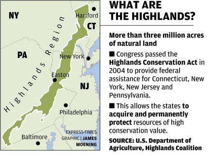
The New Jersey Highlands Water Protection and Planning Act is a comprehensive land use plan affecting eighty-eight municipalities that was passed under the McGreevey administration in August 2004 (ANJEC, 2010). The act’s environmental regulations supersede local laws of the eighty-eight municipalities contained within the Highlands Region and is instead strictly regulated by the state concerning land use and development to ensure consistency towards the goal of water protection. The New Jersey Highlands region is a 1,343 square mile region of northwestern New Jersey specifically noted for its environmental value, including its substantial water source, which over 5 million NJ residents depend on for clean water (NJ DEP, 2004). The Highlands Water Protection and Planning Act was provoked by the decline in undeveloped land area and subsequent degradation of environmental quality of the New Jersey Highlands Region. Dramatic and rapid increase in development over several decades stripped acres of forest and destroyed areas of wetlands (ANJEC, 2010). After a few decades of extensive development, the region was significantly degraded and its environmental quality diminished, affecting its natural resources – including water (NJ DEP, 2004). Increased fragmentation caused by suburban sprawl was also a major concern as it depleted habitats, vital resources, and disrupted the ecological balance of the entire region (ANJEC, 2010). The area also contains a diverse amount of natural resources including contiguous forestlands, wetlands, watersheds, and plant and wildlife habitats unique to the Highlands region (NJ DEP, 2004). Additionally, the Highlands region also contains historical sites, approximately 110,000 acres of active agricultural land, and creates recreational opportunities (NJ DEP, 2004).

The Highlands Region has an early history of faming due to the extremely fertile and productive low valley lands (New Jersey Highlands Council, 2008). Later, the region became a key area in ironworks after the discovery of rich iron oxide deposits (New Jersey Highlands Council, 2008). The natural resources of the region made the area successful early on, thus industrialization brought about a dramatic increase in population and subsequent development. Although some areas of the Highlands are still used for agricultural purposes, the area is not nearly as dominated by agriculture as it once was and is instead frighteningly overdeveloped. The significance of the region has been federally recognized for at least 100 years and throughout the last century, so individual municipalities allotted reservoirs and preserved open space. (New Jersey Highlands Council, 2008). Previous legislation has not sufficiently protected the land and water supply due to the expansive amount of real estate being controlled by seven different counties (ANJEC, 2010). Water quality steadily diminished as watersheds became increasingly contaminated and inconsistently regulated. The significance of the issue began to rise as water and land quality suffered under incompatible environmental standards and development/planning laws that each municipality had controlled. The need for a cohesive, comprehensive land use plan became intrinsically vital in securing the natural resources of the Highlands region.

The New Jersey Highlands Act of 2004 divided the Highlands into two regions: the Preservation Area and the Planning Area (ANJEC, 2010). Greater development is allowed within the Planning Area and development is strictly prescribed within the Act. The Preservation Area is more sensitive to environmental disruption and therefore restricts and highly regulates development. Ultimately, protection of the region and outlines for responsible development were prescribed through legislation and enacted into law in 2004. After thorough analysis from the Highlands Council and a public review process the Highlands Council approved the Highlands Regional Master Plan on July 17th 2008, which then became effective on September 8th 2008. In addition to providing detailed regulatory procedures the Regional Master Plan included in depth technical assessments and information to assist municipalities in conforming to the stipulations of the Highlands Act. The Highlands Act mandates that local governments conform to the Regional Master Plan and adopt ordinances to implement those plans. The Master Plan also contained expansive guidelines for the Transfer of Development Rights (TDR) Program to address the equity issues of landowners. The establishment of a regional planning body, tighter environmental regulation, and TDR programs, although new to the Highlands, have precedents in earlier Legislative action by the state of New Jersey.

The government of New Jersey has taken action on environmental quality standards and development even before the New Jersey Highlands Act. On two other accounts, the Meadowlands and Pinelands of New Jersey both inspired acts of legislation as environmental concerns arose after irresponsible development. The Hackensack Meadowlands Reclamation Act of 1969 created the New Jersey Meadowlands Commission (New Jersey Meadowlands Commission, 2010) and the Hackensack Meadowlands Municipal Committee. The thirty-mile area of the Meadowlands was previously regarded as a dumping ground, polluting that Hackensack River and its marshes and corresponding watersheds (New Jersey Meadowlands Commission, 2010). The NJMC’s mission was to restore the Meadowlands district, which had been long abused by illegal dumping and mistreatment of the land. The Meadowlands Commission is responsible for zoning and planning for the Meadowlands district while promoting economic growth of surrounding communities (New Jersey Meadowlands Commission, 2010). Similarly to the Highlands region, fourteen municipalities controlled the larger Meadowlands area separately. These municipalities created massive incompatibilities in regards to the regulation of pollution and land use (New Jersey Meadowlands Commission, 2010). Again, the State was pressured to intervene and establish a commission that was responsible for the comprehensive master plan of the region.

Another significant piece of legislation concerning the preservation of unique and necessary environments was the National Parks and Recreation Act of 1978. The New Jersey Pinelands National Reserve (1979) was created by Congress under the National Parks and Recreation Act. This identified the Pinelands region as sensitive and vulnerable to negligent development due to the habitats and resources that are found in the region (New Jersey Pinelands Commission, 2007). The Act established the Pinelands Commission, which is instated within the New Jersey Department of Environmental Protection but operates without the supervision of the department, and called for a Pinelands Comprehensive Master Plan (New Jersey Pinelands Commission, 2007). In addition to defining the boundaries and habitats threatened by increased development, the act also prescribes limitations of development within the preservation area. The 1.1 million acres of land within the Pinelands National Reserve was nationally and internationally recognized as a Biosphere Reserve in 1983 and 1988 respectably (New Jersey Pinelands Commission, 2007). Similarly to the Highlands Region, the impressive amount of land protected under the Pinelands National Reserve is underlain by aquifers containing 17 trillion gallons of pristine water, making it an important water source and water recharge area (New Jersey Pinelands Commission, 2007). In addition to being a significant natural resource, the Pinelands National Reserve also contains historic value, economic and recreational opportunities, as well as sentimental cultural value. In 1967, the publication of “The Pine Barrens” by John McPhee sparks “tremendous public outcry to protect the Pinelands natural and cultural resources” (New Jersey Pinelands Commission, 2007). Public pressure to protect the region influenced the legislation decision to allocate the Pine Barrens as a preserved site. Like the Highlands, the Pinelands contains vital natural resources which have become victim of unconscious development and under regulated environmental standards when it was controlled by a number of municipalities. The federal and state response in the late 1970s finally designated the region an area of environmental importance and in 1979 Governor Byrne signed the Pinelands Preservation Act and later approved the Pinelands Comprehensive Master Plan in 1981 (New Jersey Pinelands Commission, 2007).

 Actors Involved with the Highlands Act

The Highlands Water Protection and Planning Act affects millions of people every day, from regulating development to the quality of New Jersey’s drinking water. Since the policy has such a comprehensive power over millions of New Jersey residents, the act has an equally large amount of actors that are affected by the policy or who are involved with its implementation. The actors involved have a broad background, spanning from some of New Jersey’s farmers to the Highlands Council. This policy stands as one of the most significant environmental sustainability and development acts in New Jersey’s history. However, it is still experiencing issues regarding implementation seven years later. The policy is a point of contention because some actors are affected more negatively while others are affected more positively. This section will examine each involved actor and evaluate its power regarding implementation and their own personal agendas in the scope of the political sphere.

Arguably one of the most significant actors involved with this policy is the Highlands Planning Council. The New Jersey Legislature created the council to oversee the future implementation and enforcement of the act in 2004. There are fifteen seats on the council and the governor appoints all of the members. The Highlands Council was enumerated several powers by the NJ Legislature. This includes- developing a comprehensive Highlands Regional Master Plan, passed on July 17th, 2008; identifying areas within the preservation zone of the Highlands Region where development shall not occur; a limited authority to review and accept or reject building proposals within the Highlands Preservation Zone. The Highlands Council has developed an array of incentive to expedite implementation of the regional master plan to conforming municipalities. Those municipalities that do conform to the regional master plan are offered grants, legal assistance in case the municipality is sued, tax assistance, and the ability to engage in transfer of development rights. Those municipalities located wholly or partially within the preservation zone that do not comply with the regional master plan will meet legal action because by law they must be in compliance with the regional master plan, as well as having state funds withheld from them. Despite having several vacant seats and being shrouded in controversy, the Highlands Council has continued to approve municipal master plans that are in conformance with the regional master plan (NJ Highlands Council, 2007).

Another actor that works closely with the Highlands Council is the New Jersey Department of Environmental Protection, a state agency tasked with preserving the state and character of New Jersey’s environment. The NJDEP has its own set of rules and regulations that specifically pertain to municipalities within the preservation zone; these municipalities must comply with the NJDEP’s rules or else they will be met with legal consequences. If a proposed development lies within the boundaries of the highlands preservation zone and is defined as a major highlands development then the development may be regulated by the NJDEP. A “major highlands development” is defined as any non-residential development within the preservation area, any residential development that requires an environmental land use or water permit, or disturbs more than one acre of land. Any development that meets the criteria for a major Highlands development may be prohibited from developing within the Highlands Preservation Area (NJ Highlands Council). In recent news, the NJDEP and Highlands Council working against one another have undermined the Highlands Act. Specifically, the NJDEP approved a housing development in Huntington Knolls that the council had previously rejected. This sets a bad precedent and highlights the problem the council and NJDEP are dealing with – since two state bodies are arguing and second-guessing each other’s work (Stamato, 2009).

Opposite from the Highlands Council and NJDEP are the local government officials. These officials are composed of the mayor and councils, planning board officials, and freeholders of the 88 municipalities and seven counties within the highlands region (NJ Highlands Council, 2007). These officials have the responsibility of balancing environmental, political, and economic considerations. As a result of the restrictive nature taken towards development, many officials have voiced dissatisfaction with the current form of the Highlands Regional Master Plan, but most have complied with the master plan because of incentives offered by the Highlands Council. The officials, listening to their constituency, have raised concern over the Highlands Act’s ability to protect economic viability as well as environmental sustainability. In light of this, many officials have called for amendments to the act because for many municipalities, especially those within the preservation area, the cost benefit of compliance is too great to handle. This is so because ratables are being driven out to more development friendly areas and land values are being deflated because there has not been adequate funding set aside yet for the TDR program.

Voicing their concerns to local government officials has not been a problem for the property owners within the Highlands region. Many property owners, especially those within the preservation zone, have strongly objected to the Highlands Act. This is so because some landowners have not received just compensation for property devaluation stemming from landowners not being able to develop their properties and because ratables that would be received by business are leaving the highlands. Property owners within the planning zone have voiced less opposition to the policy but there is still objection (O’Connor, 2010). Some property owners do not want to diminish the rural character of their land that would stem from the development of a receiving zone adjacent to their property and other landowners do not want to incur new costs that would materialize from the large infrastructure projects that would accommodate new developmental growth in the receiving zones. Although many residents like the idea that they are taking steps initiative to protect the water for themselves and future generations, many landowners stand to lose something. As a result, many of the affected landowners have petitioned the government to repeal the act, albeit so far it has been unsuccessful.

In addition to the power of individual landowners to seek agenda change and alternative specification, advocacy groups have also exerted their influence the Highlands Act. The most prominent advocacy groups involved are The NJ Builders Association, NJ Future, and the New Jersey Chapter of the Sierra Club. The NJ Builders Association has been very critical of the act because it limits the ability to develop in areas of the state. They also oppose it because the TDR program has not received sufficient funding to compensate households and towns that have experienced a decrease in property values. NJ Future and the Sierra Club both support the act, but both are critical over the act’s abbreviated ability to protect the Highlands because of budget cuts stemming from Governor Christie. Now that the Regional Master Plan has been passed, the groups have tweaked their strategies and now have focused on trying to amend the language of the regional master plan to support either a more comprehensive protection of the environment – NJ Sierra Club – or support developmental interests – NJ Builder’s Association (Horowitz, 2011). Whatever the outcome will be, all of the advocacy groups listed have voiced their concern that the Regional Master Plan falls short of its goals to adequately protect the drinking water and/or the right of individuals to develop.

The time between the 2004 Highlands Act to the passing of the Regional Master Plan in 2008 has seen great change in the political arena. The officials that encompass the Highlands Council all had a voice in passage of the Regional Master Plan in 2008. Since the Governor appoints the council, in the time spanning 2004 to 2008 we have had three politically polar governors -Governor McGreevey, Governor Corzine, and Governor Christie, which is shown in the voting behavior of the council. Regarding the passage of the Regional Master Plan, with one vacancy, the fourteen-member council voted 9 to 5 in support of the Regional Master Plan. Among the five that voted against the RMP were: Council members Tracy Carluccio, Debbie Pasquarelli, Tim Dillingham, Kurt Alstede, and Glen Vetrano. These five members voted against the plan because they felt that the current state of the plan was either too lenient on environmental regulation or too stern regarding development (Horowitz, 2011). The other nine council members that voted in favor of the Master Plan, stated that they did so because they felt they were taking adequate steps to protect the Highlands. The voting behavior of the council reflects the values, both political and ideological, that the council members possess and whether they value economic viability or environmental sustainability more.

In light of the actions of the Council, it is important to address the case of Mansfield Township, the only non-conforming municipality. Just as Kurt Alstede and Glen Vetrano voted against the master plan because it didn’t protect the interests of landowners and development, Mansfield Township has chosen not to conform to the council’s Regional Master Plan. Mansfield is obligated by law to conform to the Master Plan because they are within the preservation zone, but they have chosen not to do so because the mayor, town council, and residents of the municipality feel that land price would be artificially devalued without compensation. As a result, the State of New Jersey on behalf of the Highlands Council has chosen to withhold thousands of dollars in funds owed to the municipality and will not give them up until Mansfield Township complies (Stamato, 2009). Whether Mansfield Township will continue to be nonconforming is yet to be determined. All 87 remaining municipalities in the Highlands have opted to comply with the master plan, even those municipalities within the planning zone where compliance is discretionary, because of the incentive plan offered by the council and are now in the process of having their municipal master plans be in accordance with the regional master plan. Conforming towns can look to receive tax assistance for lost ratable base, legal representation, grants, and the future benefits of the TDR.

Perhaps the most vocal group of people in opposition to the act have been local farmers in the preservation area. These farmers have petitioned the U.S. Supreme Court to hear their case against the Highlands Act. The reasons for the farmer’s disgust over the act is similar to many other homeowners in the Highlands region, they feel that the act unjustly lowers their property values because they cannot develop the land (O’Connor, 2010). As a result nobody would like to buy the farm land they cannot develop. In addition to the farmers, Republican Governor Chris Christie has been a vocal critic of the Highlands Act. In light of record state debt, the Governor has taken a hard line against state discretionary spending. As a result, Governor Christie decided to cut the operating budget that the Highlands Council uses to offer incentives to complying towns as well as a source of funds for enforcement.

The amalgam of actors involved with the Highlands Act represents a heterogeneous background. Each actor has its own personal agenda regarding the Highlands Act. As a result, the involved actors are all trying to influence the act in such a way that will reflect upon their interests most favorably.

Implementation of an Incomplete Plan: The Transfer of Development Rights Program

Screen shot 2016-11-30 at 4.36.29 PM.png

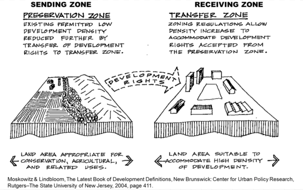
The Transfer of Development Rights (TDR) Program is a crucial component of the Highlands Act. Without it, the Act would potentially represent a politically and legally untenable scenario that would constitute an unjust taking by which property owners are stripped of the equitable value of their land. The TDR Program designates eligible properties as Sending or Receiving Zones. The value of eligible property in the Sending Zones is converted into Development Credits, which are then purchased by developers in Receiving Zones to increase the allowable development capacity of their property. The Highlands Development Credit Bank is a third party under the oversight of the Highlands Council that serves as a broker and initial financer of transfers of Development Credit. Unfortunately, the importance of the TDR program has not led to sufficient funding of the program, a situation that critics of the Highlands Act have been quick to seize upon. Nonetheless, the TDR Program has had initial success in its first phases of compensation for Preservation Zone property owners.

Sending Zones consist of properties in the Highlands Preservation Area that meet specific eligibility criteria.   Properties can be residential or non-residentially zoned. The land be must be situated in designated Protection or Conservation Zones. A parcel of land also must be at least five acres and three times the minimum lot size. Finally, and perhaps most importantly, the land must be undeveloped. Additionally, property owners of land that does not meet these stipulations can request a special determination of eligibility from the Highlands Council. (New Jersey Highlands Council, 2008)

Once a property is deemed eligible, the development value of the tract of land is converted into Highlands Development Credits (HDCs), which can then be allocated to property owners in the Receiving Zone. Once the land’s value has been converted to HDCs, a restriction preventing development is placed on the deed to the land. In order to account for the fluctuations in property value between the various regions of the Highlands, the HDC was created to be a unit of monetary exchange between property owners according to a formula (Appendix B) that scales the net yield of a tract of land according to property value and potential uses had the land been developed (New Jersey Highlands Council, 2008).   The Highlands Council has set the initial value of HDCs at $16,000 per credit. However, once the private market for HDCs has been established, the price is expected to fluctuate according to demand (Highlands Council, 2010). Once allocated, HDCs can then be sold either to the Highlands Development Credit Bank or to private landowners in the Receiving Zone.

Receiving Zones consist of tracts of land that have been designated as such by their municipalities and approved as conforming to the Regional Master Plan if they are within the Highlands or the general State Planning Commission guidelines for municipalities outside the jurisdiction of the Highlands Act.   To obtain such designation, municipalities must complete a feasibility assessment before petitioning the Highlands Council for designation, and then prepare a Transfer of Development Rights Ordinance for review and approval by the Highlands Council (New Jersey Highlands Council, 2008). Initially, only municipalities located in counties that were located in the Highlands region could apply for TDR designation. However, the 2010 signing into law by Governor Christie of the Highlands TDR Extension Bill (A602/S80) gave any New Jersey municipality the option of petitioning for Receiving Zone designation (Highlands TDR Extension Bill, 2010). Receiving Zones within the Highlands region can be designated as Higher Intensity Receiving Zones if they contain the infrastructure to allow density of over five dwelling units per acre or Lower Intensity Receiving Zones for communities that are more rural or suburban in nature and cannot accommodate residential density of five dwelling units or more per acre (New Jersey Highlands Council, 2008).

Despite the enactment of the TDR Program with the 2008 approval of the Regional Master Plan, a great deal of uncertainty remains over the financial viability of the program, leading to criticism from opponents of the Highlands Act. Initially, the TDR market was expected to be completely private. Consequently no funding was allocated to the TDR Program when the Highlands Act was enacted, leading state Senator Michael Doherty, among others, to attack the plan. According to Doherty, “There is no foreseeable plan to provide compensation to landowners who see the development potential of their land being taken away” (Robbins, 2009). Despite such bruising political rhetoric, the fact of the matter is that in issuing Executive Order 114 in September of 2008, Governor Corzine provided $10 million in initial funding to the HDC Bank for the purchasing of development credits (Executive Order 114, 2008). As of April 2011, $2.596 million of that initial fund has already been used to purchase HDCs from nine property owners (Garretson, 2011). For Doherty and other critics though, the seed money seems wholly insufficient as a means of compensating property owners in the Highlands. Indeed, a weakness of the program appears to be the need for developer demand to reach sufficient levels to create a sustainable private market for development credits (New Jersey Agricultural Experiment Station, 2011).

The Transfer of Development Rights Program is an essential facet of making the Highlands Act a viable and equitable solution to the regional planning goals of northern New Jersey. Providing compensation to landowners for the lost value of their property represents a vital step in ensuring that growth in the region is redistributed in a manner that does not create an unfair hardship to property owners. However, controversy over the program and its lack of funding has given the Act’s opponents the ammunition they needed to increase their criticism. Even after a short term solution was enacted through Executive Order 114 to ensure the TDR program’s immediate viability, the critics have continued their attacks, since the $10 million that was allocated is still not enough to fund the entire program. For the TDR Program to be a long-term success, the growth and development of a vibrant private trading market in development credits must occur as soon as possible.

Legal and Political Challenges to the Highlands Act

As one might have expected from such a controversial piece of legislation, a variety of legal and political challenges have been mustered in opposition to the Highlands Act in an attempt to repeal, revoke, nullify, or otherwise weaken the Act. Highlands litigation has been pursued on all levels of the legal system, all the way to the United States Supreme Court. In every instance however, these attempts have been unsuccessful. The courts rejected legal challenges to the Highlands Act and a legislative attempt to weaken the act ultimately resulted in failure.

The most significant litigation that took place in state courts was the 2007 case OFP, LLC v. State of New Jersey. This case involved a challenge of the constitutionality of the Highlands Act by a Morris County developer who wanted to subdivide their property.   The plaintiff argued that the Highlands Act “operates as a bar to development as otherwise permitted by law and results in a taking of OFP’s property without compensation” in violation of the Fifth Amendment to the U.S. Constitution and Article I, Paragraph 20 of the NJ Constitution in addition to a violation of equal protection and due process guarantees (OFP, LLC v. State of NJ, 2007). The New Jersey Superior Court ruled against the plaintiff in January of 2008, and was upheld by the Appellate Court and also the New Jersey Supreme Court, which refused to hear an appeal.

Also notable was the litigation pursued by Warren County farmer John Kasharian in a petition before the United States Supreme Court. In Kasharian v. The Highland Act of New Jersey, Kasharian alleged in his petition for a writ of certiorari that the Highlands Act was a violation of the equal protection rights granted in the United States Constitution. Kasharian’s argument was based on the dubious suggestion that the State of New Jersey’s enforcement of Highlands regulations represented regulatory action that should only fall under the jurisdiction of the U.S. Environmental Protection Agency (Kasharian v. The Highland Act of NJ, 2009). The U.S. Supreme Court rejected Kasharian’s petition in June of 2010.

Prior to the aforementioned legal challenges was a legislative attempt to effectively weaken the Highlands Act by neutralizing the authority of the Highlands Council. Co-Sponsored by two of the Act’s most vocal enemies, Assemblywoman Marcia Karrow and then-Assemblyman Michael Doherty (both Republicans of the 23rd District), the so-called Highlands Improvement Act (A2915) would restore elements of home rule that had been removed by the Highlands Act. A2915 would create a board of elected officials from local municipalities to oversee the Highlands Regional Master Plan in an action that would strip a significant amount of regulatory control from the Highlands Council (Highlands Improvement Act, 2006). However, the Highlands Improvement Act died in committee and did not reach a vote (Highlands Improvement Act, 2006).

Land Assessments

Since the boundaries of the Act were created objectively, numerous issues arose. Data regarding property lines, land value, or mathematical equations were not incorporated. The area within the Act was drawn on a map and then enforced. Thus the authors of the Act neglected to physically inspect the lands. Since this Act bans “major development on hundreds of thousands of acres in northwestern New Jersey.”(Conner, 2010) An assessment of land properties could have helped to incorporate financial levity. The Act covers a large region and affects many municipalities and many landowners. The absence of such assessments led to many residents loosing financial assets. The economic losses cannot even be calculated.

Many issues stem from grouping together so many municipalities from such a large region. The Act incidentally combined different ecosystems and environments together. Each municipality has very different conditions, suburban sprawl patterns, and population densities. As a result, the Act should have acknowledged these differences.

Since the Act is already implemented, such recommendations may not be technically feasible. However, since the Act is continually updated future recommendations can be made. Any land that is going to be added or taken out of the Highlands region can be physically assessed.

Alternate Funding of Transfer of Development Rights

Initial funding of the TDR program came from a $10 million capital fund. Yet TDR programs only benefit a small number of affected landowners. The TDD programs are factored from size, location, and zoning of property. Resident’s land is based market value from 2004. These market mechanisms are based on the free market and intend to be prosperous. Like most market based initiatives, alternate funding needs to be made in order to make the TDR program economically solvent.

A way to additionally fund the TDR’s in this region is a nominal water consumption surcharge. Several municipalities have proposed this tax. Municipals within the Highland’s region believe the Act’s “development controls and related costs are imposed on but a few watershed communities, while hundreds of northern New Jersey municipalities stand to benefit immensely from safer and more abundant water supplies as well as improved ratable growth opportunities.” (Borough of Ringwood, 2005) This is a recommended policy because it is practical and feasible.

Improve Transportation Infrastructure

Since this Act greatly affected land-use within the region, transportation was also affected. Suburban sprawl was halted, promoting high densities in other regions. In addition, since receiving zones are going to receive transferred growth from the preservation areas, transportation accommodation must be made. An increase in transportation infrastructure will be needed. This will be needed in order to maintain population growth and density.

Roads and connectivity could be subsidized and maintained. More parking lots could be added to popular destinations. Public transportation can be redeveloped and emphasized. Also, transit oriented development can be promoted.   While continually updating transportation infrastructure and decreasing suburban sprawl, municipalities can better aid their residents.

Redevelopment Promotion

The Act takes a lot of land from people and makes their land unusable. The government has to provide compensation and economic liquidity. This economically affected so many residents and landowners. Therefore, the Committee should promote redevelopment. Redevelopment of central business districts and depreciating areas should be promoted.

The TDR program will dramatically increase population in the receiving zones. These areas should be of concern. Whether residential or commercial, strategies will need to be included to accommodate newfound growth. Land uses will change. Strategies like mixed-use zoning will be necessary.

Amend Planning System

The idea of changing the planning system of the Highlands is another option. Fifteen members currently govern it. These fifteen members include “public officials and citizens from the Highlands region, as well as representation from both major political parties.” (Rutgers 2011) More municipal or state representatives could be added. Also a group of farmers could be added to the Committee to increase their voice in matters. This option failed to gain traction in the Doherty-Karrow Highlands Improvement Act of 2006 (A2915). However, it is still a potential recommendation.


Works Cited

ANJEC. (2010). “New Jersey Highlands.” Association of New Jersey Environmental Commissions. Retrieved April 5, 2011 from http://www.anjec.org/NJHighlands.htm

Borough of Ringwood. (2005). Resolution Number 2005-222. Retrieved April 24, 2011 from http://www.ringwoodnj.net/content/100/124.aspx

Garretson, Craig. (2011, January 25). HDC Bank to Consider Third Round Offers [Press release]. New Jersey Highlands Council. Retrieved April 20, 2011 from http://www.highlands.state.nj.us/njhighlands/news/pres/hdc_bank_012511.pdf

Hasse, John. (2003). Analyzing Urban Sprawl in New Jersey. Department of Geography and Anthropology, Rowan University, Glassboro, NJ. Retrieved April 26, 2011from http://users.rowan.edu/~hasse/

Highlands TDR Extension Bill of 2010, A602/S80. (2010). Retrieved April 16, 2011, from http://www.njleg.state.nj.us/2010/Bills/PL10/7_.HTM

Highlands Improvement Act of 2006, A2915. (2006) Retrieved April 16, 2011 from http://www.njleg.state.nj.us/2006/Bills/A3000/2915_I1.HTM

Horowitz, Ben. (2011, April 3). “N.J. Highlands Council Continues Approving Towns’ Development Plans, Despite Vacant Seats, Criticism.” The Star Ledger. Retrieved April 25, 2011 from http://www.nj.com/news/index.ssf/2011/04 /nj_highlands_counci l_continues.html

Kasharian v. The Highland Act of New Jersey, 2009 U.S.S. Ct. Briefs LEXIS 3078. (2009)

Lockwood, Jim. (2010, April 22). “N.J. Highlands Group Urges Christie to Protect ‘Drinking Water for 5.4 Million People.” The Star Ledger. Retrieved April 25, 2011 from http://www.nj.com/news/index.ssf/2010/04/nj_highlands_group_urges_gov_c.html

New Jersey Agricultural Experiment Station (2011). “Summary of the New Jersey Highlands Water Protection and Planning Act.” Rutgers University. Retrieved April 20, 2011 from http:najes.rutgers.edu/highlands/

NJ DEP. (2011). New Jersey Department of Environmental Protection Web Site. Retrieved April 25, 2011 from http://www.state.nj.us/dep/

NJ DEP. (2004). “DEP Guidelines for Highlands Water Protection and Planning Act.” NJ Department of Environmental Protection. Retrieved April 4, 2011 from http://www.state.nj.us/dep/highlands/index.htm

New Jersey Executive Order No. 114 (2008). Retrieved April 17, 2011 from http://www.njhighlandscoalition.org/PDF/EO114.pdf

New Jersey Highlands Council. (2007). New Jersey Highlands Council Web Site. Retrieved April 25, 2011 from http://www.highlands.state.nj.us/njhighlands/

New Jersey Highlands Council. (2008). Highlands Regional Master Plan. Retrieved April 4, 2011, from http://www.highlands.state.nj.us/njhighlands/master/rmp/final /highlands_rmp_112008.pdf

New Jersey Highlands Council. (2010). Highlands Transfer of Development Rights Program Overview. Retrieved April 20, 2011 from http://www.highlands.state.nj.us/njhighlands/master/tdr/tdr_over.pdf

New Jersey Meadowlands Commission. (2010). “History of the Meadowlands.” New Jersey Meadowlands Commission. Retrieved March 29, 2011 from http://www.njmeadowlands.gov/about/timeline/history_F.html

New Jersey Pinelands Commission. (2007). “The Comprehensive Management Plan.” New Jersey Pinelands Commission. Retrieved April 25, 2011 from http://www.state.nj.us/pinelands/cmp/summary/#activities

O’Connor, Julie. (2010, April 27). “Farmland Owners Petition U.S. Supreme Court to Overturn Highlands Act.” The Star Ledger. Retrieved April 25, 2011 from http://www.nj.com/news/index.ssf/2010/04/farmland_owners_seek_to_overtu.html

OFP, LLC v. State of New Jersey, 395 N.J. Super. 571. (D. 2007)

Robbins, Gene. (2009, December 1). “New State Senator Michael Doherty Targets Highlands Council, State Spending.” The Warren Reporter. Retrieved April 17, 2011, from http://www.nj.com/warrenreporter/index.ssf/2009/12/new_state_senator_michael_dohe.html

Stamato, Linda. (2009, May 16). “Environmental Controversy, New Jersey Style: The Highlands Council and the NJ DEP.” NJ Voices. Retrieved April 25, 2011 from http://blog.nj.com/njv_linda_stamato/2009/05/environmental_controversy_new.html

Water.org. (2008). Water Facts. Retrieved April 26, 2011 from http://water.org/learn-about-the-water-crisis/facts/


Appendix A: Timeline of Significant Events


Timeline

1969: The Hackensack Meadowlands Reclamation Act created the New Jersey Meadowlands Commission (NJMC) and the Hackensack Meadowlands Municipal Committee.

1979: Governor Byrne signed the Pinelands Preservation Act/NJ Pinelands National Reserve passed by congress

1981: Pinelands Master Plan approved

2003: Governor McGreevy assembled the Highlands Task force in 2003 to get advice on a plan that would preserve the water in the NJ Highlands Region

2004: The NJ Highlands Act was passed/establishes the Highlands Protection Fund, to provide grants to county and local government to assist in planning efforts related to conformance with the Act

2006: Doherty-Karrow Highlands Improvement Act would restore elements of home rule that had been removed by the Highlands Act and would create a board of elected officials from local municipalities to oversee the Highlands Regional Master Plan in an action that would strip a significant amount of regulatory control from the Highlands Council. However, the Highlands Improvement Act died in committee and did not reach a vote

2007: OFP, LLC v. State of New JerseyàThis case involved a challenge of the constitutionality of the Highlands Act by a Morris County developer who wanted to subdivide their property. The plaintiff argued that the Highlands Act “operates as a bar to development as otherwise permitted by law and results in a taking of OFP’s property without compensation”.

2008: JanuaryàSupreme Court Ruled in favor of the State of New Jersey

2008: September 8th Highlands Council approves the Highlands Regional Master Plan –Highlands Development Credit Bank becomes operational with the approval of the Highlands Regional Master– Governor Corzine issues Executive Order 114 that instructs the State of NJ to allocate $10 million to the Highlands Development Credit Bank

2009: Kasharian v The Highland Act of New JerseyàFarmer John Kasharian alleged that the Highlands Act was a violation of the equal protection rights granted in the United States Constitution. Kasharian’s argument was based on the dubious suggestion that the State of New Jersey’s enforcement of Highlands regulations represented regulatory action that should only fall under the jurisdiction of the U.S. Environmental Protection Agency

2010: The U.S. Supreme Court rejected Kasharian’s petition in June.

2010: Governor Christie signs A-602/S-80, the Highlands TDR Extension Bill gave any New Jersey municipality to serve as a voluntary receiving zone for Highlands Development Credits

Appendix B: Formulas for Calculation of Development Credits 

Residential Property

UNET x KZF x KLF = HDC Allocation

UNET = Net Yield – the number of residential lots that could have been situated on a parcel of land on August 9, 2004, taking into consideration all municipal development regulations and applicable state and federal laws and regulations.

KZF = Zoning Factor – a regional adjustment factor to recognize that the value of the land varies according to the end use to which the property could have been developed.

KLF = Location Factor – an adjustment factor to recognize that per unit value of land varies by location within the Highlands Region.

Non-Residential Property

UNET ÷ KSF/USE = HDC Allocation

UNET = Permitted Square Footage the amount of buildable area that could have been situated on the parcel of land on August 9, 2004, taking into consideration all municipal development regulations and applicable state and federal laws and regulations.

KSF/USE = Non-Residential Square Footage Conversion a conversion factor between various types of non-residential uses recognizing differences in underlying land value associated with various non-residential uses.


Source: Highlands Regional Master Plan, Pages 358-9
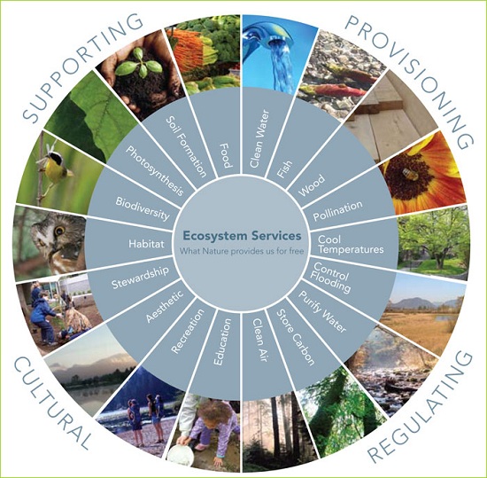
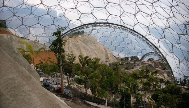
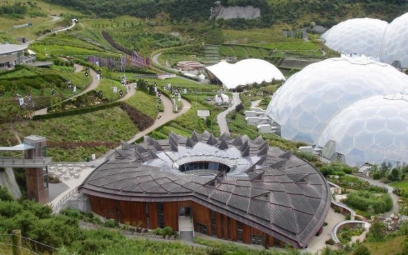
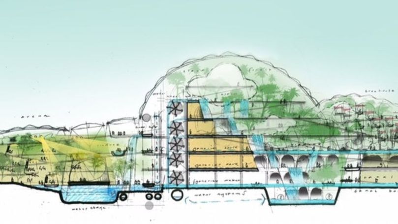


The Digital City

smart-city-w

The Digital City

“Cities have the capability of providing something for everybody, only because, and only when, they are created by everybody”-Jane Jacobs, The Death and Life of Great American Cities

Today’s cities are growing at an alarming rate. It is estimated that more than half of the population now lives in urban areas. The U.N projects that by 2050, nearly seventy percent of people will reside in cities.[1] Two hundred years ago, only three percent of the world’s population were urbanites.[2] People once had to inhabit areas close to agriculture and water sources. With technological advances, developments are no longer centered on such physical constrictions. Modern cities are complex hybrid realities of technology and place-based infrastructure, in which our social fabric is built and defined. Cities have become hubs for human connections, creativity, and green living. Paradoxically, cities also host the most severe cases of pollution, crowding, crime and social fragmentation. Now, more than ever, cities need a vision for a future in which technology and humans function in symbiosis. Together, humans and technology possess the capabilities to transform city spaces into sustainable, beautiful, and efficient places. The cities of today require a new paradigm for digital infrastructure. The modern metropolis will incorporate innovative and smart places, software that activates these places, and spatial configurations that meld together the digital world with a physical location for organization.

Technology has enabled an electronically interconnected world in which distance is no longer an impediment to connectivity. “Mind-work no longer demands legwork, commerce is not impeded by distance, and community does not have to depend on locality”2 The Industrial revolution coupled with the Interstate Highway Act resulted in the separation of home and work, thus creating automobile dependence and sprawl. The digital revolution is bringing them back together through electronically enabled home and work places. Spaces can now function simultaneously to serve several purposes. The digital metropolises of the future will require new urban tissues characterized by live/work dwellings, mixed-use communities, and widespread electronically mediated meeting places. This provides a framework for more sustainable, walkable and efficient cities. This new paradigm will require planners, urban designers and architects to create new infrastructure, which melds together new and old values of urban living. Architecture and urban design will have to optimize the relationships between physical and virtual spaces. The city is becoming spatially constituted as a hybrid: the digital and physical world merge, thus technological and material edges are becoming increasingly hard to dichotomize.[3] The hybrid age has produced a socio-technical nexus of co evolution between humans and technology.

The twenty-first century metropolis is becoming less determined by discrete objects and increasingly shaped by the connectivity between them.[4] Technology is enabling a new reality; architecture and physical spaces are being programmed to adapt to various conditions and respond to the environments in which they function. These buildings, objects and systems are becoming intelligent consumers of resources. The “smart places” of the future possess many of the characteristics of living organisms: interconnected and self-aware systems that integrate sensory inputs from multiple sources.1 Inhabitation takes on a new meaning: electronically mediated places are a combination of IP addresses and street addresses with electronic linkages. They are simultaneously embedded in and sustained by systems of physical and material circulation, visual and acoustic communication, and remote interconnection. An architecturally defined space now connects with the nervous system through nearby electronic organs. [5] Physical spaces will become a part of humans and humans a part of them. In the hybrid age, distinctions between “self” and “other” are being reconstructed.

The physical spaces that once sat idly now possess semantic memory. Algorithms and voracious data collection allow our cities to communicate with us and us with them. These technological mechanisms have situational awareness: able to consolidate, monitor and analyze data.[6] Through technological systems, our cities have semantic knowledge of people, objects, actions, relations, and culture that are acquired through experience.[7] By corresponding with citizens and other data sources, these systems act as a neural web that is constantly communicating in real-time and learning from other “data cells”. This enables an “internet of things”, in which data sensors embedded in streets, buildings, cars and other objects will transform physical objects and people into communicative systems. The Hybrid Age enables a reality in which all electronic devices act as sensors: counting steps, flashing warning signals at oncoming cars, and monitoring environmental conditions. These systems will be seamlessly linked in a wireless “bodynet”: allowing humans and technology to act as an integrated and semantic system that function in a worldwide digital network.5Author William Mitchell argues that through this semantic knowledge base, humans have transformed into modular re-configurable, infinitely extensible cyborgs.5 Theoretical physicist Michio Kaku claims that the “computer” as an object will cease to exist from view and instead become invisibility integrated into our built environment.[8] In this way technology has become as omnipresent as the air we breathe.

In many ways, virtual systems are taking over physical space. Storage of bits is displacing storage of physical artifacts, thus reducing the need for building.5 Moving bits is more efficient than moving people and goods. The result is a reduction in fuel consumption, pollution, land use, and travel time. Many physical spaces are increasingly being substituted by electronic systems. As population increases, smart growth becomes essential to combat sprawl, automobile dependence, and overcrowding. This means creating communities that are well planned, efficient and economically viable. Cities need to respond to the changing values of young urban professionals. Apartments will become hyper-efficient, technology-enabled spaces that dynamically transform and do more with less space. In addition, built in computational components will adjust for resource efficiency. Hong Kong has exemplified this concept through a 334 square foot space, which can be transformed into 24 different configurations.1 Technologically enabled walls can slide and rearrange themselves while other objects: kitchen, dining, dressing, and bed–can be rearranged and moved automatically depending on the residents needs. With these CityHomes, residents can now reside in personalized dwellings that are more scalable, livable and functional. One size never really fitted all, and now it doesn’t have to. Things can be created in non-standardized ways with elements that respond precisely to the users needs.

Places now possess the capabilities to respond to the availability of more or less resources such as wind, sunlight and water.4 The problem of scare resources will be addressed through semantic technology: Agriculture that regulates soil moisture, computers that download large files from the Internet in off peak hours, and houses that self-regulate. The needs of cities and the humans residing within them will be anticipated before citizens are conscious of them. The “internet of things” will allow objects to react to stimuli from other inputs and adjust their actions accordingly.1 “Smart houses” will monitor internal temperatures, ambient light levels, room-by room sound and motion, and outdoor weather conditions. They will continuously process and consume data and interact with the software delivered through devices in the homes and those worn by inhabitants. In the future sensors will be embedded in even more devices, collecting, utilizing, quantifying and analyzing the processes of urban life.1 Cities can now anticipate things that humans cannot and create feedback loops allowing for the optimization of how cities function. Systems are now capable of applying and imbuing the adaptive intelligence of biological processes into synthetic and technological biology. Using living materials coupled with the use of technology, cities can harvest carbon dioxide and produce energy. Any corner of a busy street could receive 50,000 steps a day; cities now have the potential to utilize pedestrian traffic by harnessing kinetic energy in highly active areas with Pavogen Tiles. Cities could be more than simply efficient; they could become sites of resource production rather than voracious sites of consumption.

Urban regions are made even more efficient through spatial enablement and geo-location. When planned and implemented properly, citizens can interact with and through space using technology in a meaningful and empowering way.6 A water pipe is able to tell a computer it is fractured, a car is able to tell when the driver is veering off, and an apartment is able to determine if there is a gas leak or a fire and immediately alert authorities. The possibilities of these geo-tagged sensors and data practices are endless. Geo-crowdsourcing possesses the faculty of real-time emergency management and open sourced citizen input and feedback.6 Citizens act as sensors to report inefficiencies and problem areas within the city such as potholes, which municipalities can then address before they become too costly. Devices such as smart phones further accelerate Semantic Cities. Singapore used mobile phones and other urban sensor data to create a real-time map of the busiest restaurants, most congested transportation routes, and other information.1 Users can report various incidences, find ride shares, and even locate where their favorite items are on sale. Localized reports on air quality can be crowdsourced to help those with asthma and allergies. Googlemaps traffic layer allows users to overlay real-time information about traffic volumes and other information passively and anonymously. The result is an accurate tool to avoid traffic jams and even potholes.1 Cities would not function as they do without this open-sourced citizen data; it is an integral part of the vast and dynamic network of “smart cities”.

Technology can increase the function of cities as a place for mobilization and civic participation by bringing together residents of diverse backgrounds. Technology as far as urban politics are concerned has allowed cities to be transformed into places, which enable “electronic democracy”. Today over 1,000 towns and cities have homepages and more than 200 already have civic networking projects.[9] These provide new channels for access to political information and introduce opportunities for transparency, immediate feedback loops and civic participation. This substitutes the inconvenience of attending 7pm planning board meetings on a Tuesday or Thursday. This form of online civic participation allows for strengthened interactions of voluntary organizations, pressure groups, and other computer-mediated communication. Technology is a means to reach supporters and share information and resources. In this way, it can encourage less red tape and more results. Intraurban networks have the potential to provide updated versions of the agoras and forums of the past. Accelerated connectivity enables more autonomous forms of community.8 Citizens are enabled to demand real-time accountability and transparency from politicians. The Jeffersonian Dream has been encouraged and reinvigorated by “community networks” and supported by online meeting places.2 With shrinking municipal budgets it is important that citizens have an online platform to collect, communicate and engage within the urban context.

As the definition of “neighbor” is becoming increasingly colluded, cities need to focus on building human capital and reconnecting citizens in face-to-face spaces as well as in the digital realm. Online databases provide organizations, institutions, and individuals with short feedback loops, networking, transparency, and collaborative capabilities in which assets can be visualized and leveraged. Various parties can build partnerships and strategic alliances by observing common interests and organizational links. These relationships relate to funding, referrals, access to resources, joint service planning, and collaborative projects. This strategy of an online map of assets helps identify gaps and inefficiencies and allows for the more effective and cohesive achievement of unified goals. This “digital Community center” brings together stakeholders and eliminates the redundancy of resources and needless expenditures.

A unified coalition allows for the ability to influence power structures, leverage resources, and gain business support. Many applications are enabling citizens to share in a “location based social network” where they can engage/disengage in communication. These virtual meeting spaces provide a framework to encourage social gatherings in both the physical and technological realms. Applications such as Instamapper, Meetup, Foursquare and Spotme combine geo-location and social networking, thus linking together virtual and physical worlds into a platform for meeting. Grassroots planning through online systems such as Plentizen–an online planning website–make movements such as guerilla urbanism possible. Citizens collectively engage to host events. This tactical urbanism can be used in arts, politics, planning, science, and numerous other functions.1 Tactical urbanism is both a bottom-up and a top-down approach, which uses bridging and bonding capital to encourage civic engagement.

Technology also encourages the idea of the “collective”, resulting in the changing of citizen behaviors. By recognizing capabilities within a community individuals are mobilized with a cohesive vision and a plan to solve their own problems. Technology enables the city to function as a commons: A set of resources that belong to the collective of citizens.3 The very thing that makes cities so powerful—the ability to agglomerate—will be enhanced by a new paradigm in sharing. Technology is a catalyst for collaborative consumption: You can share everything from carbon emissions to vehicles. In cities, either consciously or subconsciously, people are beginning to realize that the public realm, the commons and the sharing goods and services are integral parts of urban life.1 The beauty of this is that people no longer need to endlessly consume goods that they will only use once. Instead, they can rent them or share them using various technological tools. Studies suggest that one shared car can take 13 or 14 off the road.1 The Internet has allowed citizens to expand the circle of people to whom they trade with. The open-sourced and collaborative culture of the web has taught people that sharing is a default of social interaction. Sharing is not just an altruistic idea that is taught in pre-school; it is an integral survival strategy that addresses some of cities most pressing issues.

The power of the crowd is crucial to the future of cities. According to Carlo Ratti, MIT’S head of Sense-able Cities. “They are more like a shifting flock of birds or shoal of fish, in which individuals respond to subtle social and behavioral cues from their neighbors about which way to move forward”. Providing awareness through direct feedback mechanisms will impact selfish behavior and reduce the inequitable overconsumption of scarce resources referred to as “The Tragedy of the Commons”. A peer-to-peer governance model will help prevent this tragedy. In an installation by artist Usman Haques, participants received a flower box with watering equipment and a bottle of vinegar. They also received an electrical appliance that was linked via the Internet to the flower boxes. If digestion of the plants offset the electrical appliance, the plants would be watered by the system. However, if all users in the system used more energy than their plants consumed, the system would start to kill plants by using vinegar.3 By utilizing technological resources, people are being turned from individual victims to collective groups with a system in place for remediation. These technologies challenge the suburban mindset that all of us in interdependence should live independently on wheels and accumulate goods excessively.

“Big data” Is drastically altering how our cities are being run and how we live within them. It possesses an invaluable utility in leveraging collective information such as environmental monitoring and emergency management. Unfortunately, there is an undeniable “big brother” element to real-time data collection and monitoring. It is hard to engage people into being human data sources due to the “Orwellian” reality of the situation. Privacy concerns must be addressed so that citizens are more aware and informed about how data is being used and collected. There is a challenge in maintaining a balance between providing pervasive real-time information and preserving privacy. The more aware citizens are of these process and the more they will benefit from these systems, the more likely they will be willing to share this data.[10] Technology is a double-edged sword, reducing burdens for some while creating them for others: we enrich our social lives through co-design in social networks, but our privacy has been compromised in the process.9

In order for these technologies function effectively, citizens should get to choose how much data they share, with whom, and how it will be used. Rather than trying to control individuals using technology, these “smart cities” must work for the people within them. The autocatalytic city contains an intelligence and ingenuity that can never be captured by a top-down system of control. To be successful it requires a bottom-up asset-based strategy and a transparent governance system. These cities should be citizen-centric rather than citizen dominated. These cities must challenge the “If you build it they will come” mindset. As argued by urban activist Jane Jacobs, our goal is not to command the city but to understand the processes that make it work.


Read More »

East Brunswick Community Park Management Plan

I Introduction

Site Location

screen-shot-2016-11-10-at-8-46-58-pm

The East Brunswick Community Park in Middlesex County is located within close proximity to I 95 on 350 Dunhams Corner Road. The site is comprised of a 40 acre wooded area as well as an aquatic park, known as Crystal Springs Aquatic Center. The entire 102-acre site is a unit within the Division of Parks and Recreation. Crystal Springs Community Park is one of the larger public spaces in the area and offers the community many opportunities for outdoor activities including basketball courts, tennis courts, and volleyball courts. Additionally, it offers many water-based activities such as boating, fishing, Skating, and swimming. There are other areas in the park for outdoor enthusiasts to enjoy themselves with hiking trails, natural areas and picnic areas. A large portion of the East Brunswick Community Park is designated for open space preservation. The Unique combination of uses on this site makes it an ideal location for citizens of all ages to enjoy both active and passive recreational uses.

The park currently has two entrances on Dunhams Corner: One that brings visitors to The Division of Parks and recreation building as well as a skate park and tennis courts. The second entrance, where the aquatic park is located, brings visitors to the wooded area of the park. There is a large and underutilized gravel parking lot located between the wooded area and Aquatic center. The rear portion of the park is adjacent to residential areas that are located on Stage Coach Run and Valley Forge Drive, however these residents currently do not possess direct access from their properties to the site. The adjacent properties to Dunhams Corner, located near the front portion of the park, include the East Brunswick Recycling Center, Concreteworks Studio East, The Brookview Volunteer fire Company, and baseball fields. The entire park area is within a five-minute walk, however current pedestrian infrastructure inhibits the circulation surrounding and within the site. The Site has a natural sentiment with its wooded area and surrounding bodies of water.

History

East Brunswick experienced a growth in industry in the 19th century that was facilitated by the abundance of raw materials, proximity to large markets as well as relatively inexpensive transportation routes to New York and Philadelphia markets. The sandy, clay soil in the area was very well adapted for the manufacturing of products such as brick and clay. Originally a farming community, improved road access in the 1930’s facilitated suburban settlement. Large-scale housing and road construction, especially after World War II, transformed East Brunswick into a more suburban community. East Brunswick Community Park has an interesting history, with a now paradoxical use. The site was once used for industrial purposes: with a mining operation for sand, clay, and gravel extraction. When the miners dug too deep and hit the springs, they could no longer operate. The Township took ownership of the property with the use of the Green Acres land trust program and converted it into a Community Park. The legacy of this mining can still be seen on the site. The man made excavations have since filled with water, becoming what is now known as Crystal Springs Lake.

The first full time superintendent of Recreation was appointed in 1969, and in 1971 the first Department of Recreation and Parks was created. The Department of Recreation, Parks and Community services operates under the guidance of a 15 member advisory board established by local ordinance. In the early 90’s the community was prompted to build an aquatic park after membership at a 30-year-old, locally operated lake facility dropped. The lake was a big income generator for this tax-exempt parcel and the site began costing the town too much money to maintain. Officials hoped that the new aquatic park would increase membership and be self-sustaining. Crystal Springs become the first municipal water park in New Jersey. The park was funded with a bond issue of two million dollars, which is being paid back over 20 years with the profits from the park. It now serves over 45,000 residents and is available to non-residents as well. During the summer the closes at 10:30 pm and attendance averages between 1,500 and 1,800 people per day.

II Statement of Park Purpose:

Mission Statement:

The East Brunswick Department of Recreation, Parks & Community Services is committed to enriching the quality of life for residents by developing and providing affordable activities, programs, community resources and leisure opportunities.  

The East Brunswick Zoning Ordinance and Zoning Map designate this site as being within the Rural Preservation Zone: The Intent of this Zoning District is to retain the largely undeveloped and rural character of SW East Brunswick. This zone also supports the objectives of the State Development and Redevelopment plan: conservation of open space and retention of large contiguous areas of agriculture

The intentions set forth in the Zoning and Master Plans, which govern land use, are utilized in terms of guiding the development and management of the park.

According to section 228-6.2 of the Zoning Ordinance:

The purposes of the RP Single-Family Rural Preservation District are:

  1. To promote the retention of existing agricultural lands and to support ongoing agricultural activities through a combination of land use policy, acquisition of development rights, creative development techniques and limitations on land use activities that interfere with continued farming;
  2. To retain the largely undeveloped and rural character which pervades western and southwestern East Brunswick, in part by limiting the introduction of growth-inducing infrastructure
  3.  To provide land use management strategies that promote the conservation of sensitive natural resources and which limit the impact of future development of this area
  4. To promote the conservation of open space through public acquisition, acquisition of less than fee interests and implementation of land use policies supportive of permanent preservation of open space areas;
  5. To support the objectives of the State Development and Redevelopment Plan including the retention of large contiguous areas of agriculture and open space, and providing for development which respects the carrying capacity of land and water resources while also preserving unique and sensitive natural areas.

East Brunswick Master Plan Statement of Goals and Objectives:

  1. To conserve as many environmentally sensitive areas in the township as feasible, with particular attention given to wetlands, areas with steep slopes, and those areas which are served by septic systems but which have seasonally high water tables
  2. To encourage existing agricultural areas to remain
  3. To develop coordinated open space and recreational programs, both for improving utilization of existing areas as well as newly acquired park areas
  4. To continue to relate school and park areas to existing and future development patterns
  5. To provide quality education at all levels for residents of the Township
  6. To develop a safe, efficient, local circulation system with maximum convenience and minimum adverse effect on land traversed

Recreation and Open Space Plan:

  1. Provide for both active and passive recreation areas, identifying environmentally sensitive conservation areas such as stream corridors and contiguous bands of wetlands

III Statement Of Park Significance

East Brunswick Community Park is one of the 15 Public Park and recreation facilities within its 984 acres of park land and private and public open spaces. As one of the largest parks in East Brunswick, it is a vital area for the regional community in terms of its environmental, educational, recreational, and economic assets:

  1. The site hosts a variety of community activities and programs such as a summer camp and fairs
  2. The park has environmentally sensitive areas such as wetlands that are vital in terms of habitats, water retention, air quality, pollutant filtering, and education

    hebuflower
    Swamp Pink
  3. Home to Endangered species:Swamp Pink
      1. Located within East Brunswick
      2. Bloom between March-May
    1.  Indiana Bat
      1. Lives within forest areas of New Jersey
      2. Range encompasses East Brunswick
  • Bat homes/feeders located on site
  1. The park enhances the surrounding agricultural and residential communities: improves home values and desirability
  2. The location near Route 18, I 95, and Route 1 make it a park that can easily be utilized by the larger region
  3. The Aqua Park does not use tax dollars, but rather entrance fees to pay for maintenance and Improvement. It is vital for the generation of funds
  4. The location of the Aquatic Park to the adjacent wooded area and athletic infrastructure makes it an excellent resource for family outings, environmental education, and the building of community capital.
  5. Home to the building of the Division of Parks and Recreation
  6. Entire Site is within a 5 minute walk

IV Demographics/Community Conditions

Growthscreen-shot-2016-11-11-at-5-57-57-pm

New Jersey has the highest population density per unit of land area in the United States. It is estimated that New Jersey will reach build out by approximately 2015. The saturation of people in the landscape of New Jersey and economic trends suggest that the population is not likely to drastically grow. East Brunswick has approximately 47,512 residents with a population density of 2,189.6 people per square miles. According to 2010 Census Data: from 1990 to 2010, East Brunswick grew 14.13% compared to 12.99% in NJ and a National population growth of 24.02%. In New Jersey this density is both a threat and an asset. The marginal availability of open space will require State Officials and stakeholders to come up with creative solutions in terms of land use appropriation, designation, and design. It will become increasingly important that open parcels of land supply a variety of functions in order to serve both ecological services and recreational opportunities for a diverse demographic.

This density will also enable an increase in more pedestrian oriented linkages and circulation to the parks and open spaces within New Jersey municipalities. With the threat of peak oil and sprawled patterns of development, it is of dire importance that the principles of Smart Growth and New Urbanism be implemented. In East Brunswick 25.62% of the population spends more than 60 minutes driving to work, and 84.25% use an automobile as a mode of transport to work. Therefore, making open spaces pedestrian oriented is important. Putting more of these uses within walking distance is critically important to achieving a more community oriented environment and stronger social-ties within these communities. Enabling more people to use the streets, public spaces, and walkways will also increase the vitality and perceived security of the area. 

Age

The United States is facing an interesting shift in terms of an aging population. East Brunswick has a median age of 43. 24.1% of the East Brunswick community is below the age of 18 and 32.1% are between the age of 45-64 years old. Compared to New Jersey as a whole with 14.56%, 17.50% of East Brunswick residents are between 45-54 years old. Residents between 18-24 make up around 7.3% of the population in East Brunswick. There is an untapped potential to attract this age demographic from surrounding areas such as New Brunswick, which has a high percentage of University students in this age bracket. These students have the potential to partner with The Division of Parks and Recreation to conduct research, volunteer, and intern.

The average household size is 2.8 with 79.9% family households. Compared to 4.9% in the State, East Brunswick has only 2.5% of households with unmarried partners. This data suggests that East Brunswick is a relatively family oriented community that could benefit from an enhanced area for family outings and activities. It is important to understand that parks and open spaces are intended to serve a variety of age groups. The park is currently focused on attracting a younger demographic, although the management plan will attempt to diversify uses and bring residents of all ages to the site.

V Environmental Analysis

Wetlands/Floodplains 

The site is Located within the 100 year flood plain and with wetlands, ponds and streams

Screen shot 2016-11-11 at 6.17.15 PM.png

Due to the environmentally sensitive nature of wetlands in addition to the threat of flooding, major commercial or residential development on this land is not recommended. 

Soil Survey 

Soil Report

Screen shot 2016-11-29 at 4.58.13 PM.png

The majority of the site is classified as Sassafras Loam Soil. These soils are categorized as prime farmland, which means that they are among the most productive soils in the state for agriculture and forestry. Therefore, uses should remain as forestland with the possibility for some land set aside for agricultural use.

VI Primary Interpretive Themes

Currently this site has a very small online presence. What is conveyed to the public is the importance of the Crystal Springs Aquatic Center. The Website focuses on the Water Parks importance in terms of recreation, field trips, summer camps, and other events. Focusing solely on the Aquatic Center represents a failure to utilize and interpret many of the assets and environmental functions that exist within the site. Ignoring the other areas of the park goes against the intent of the Zoning Ordinance and Master plan in terms of recognizing the function of open space as a place for environmental protection, conservation, and education for all age groups. A lack of attention given to the natural wooded area and other recreational facilities has resulted in blighted buildings and infrastructure. This has led to virtually no interpretation of any themes other than that the site is a Water Park.

This Management plan will attempt to remediate the lack of attention and focus given to the natural areas. The Water Park possesses the means of drawing in visitors to the adjacent uses (if infrastructure is updated). The main interpretive themes this site will convey are as follows:

Environmental Education: The site will use strategic infrastructure, planning, and educational resources to teach visitors about the importance of resource management, environmental responsibility, and ecological services/functions. This information will be catered to various age groups.

Water Management: The importance of protecting, preserving and enhancing water resources should be emphasized. Education about wetland and watershed preservation will be conveyed to visitors.

Flora/Fauna: The importance of biodiversity ands its preservation will be conveyed to guests. Education on endangered species will be an integral part of the program. The flora of the earth produce the oxygen that  is then breathed by the fauna-the fauna exhale the carbon dioxide that the flora need to live. Man has created a world in which the ecological balance of flora and fauna has been destroyed, in many instances causing the extinction of entire species. If  this is partially due to environmental ignorance, perhaps such programs can eradicate part of the underlying problem.

Agriculture: The site is in a Rural Preservation district, therefore it is important to educate visitors on the importance of local food production. This will be done through fairs with local farmers and artisans. Agricultural education will come from the community gardens, greenhouse exhibits, and a food forest (which will teach about permaculture, companion planting). This is especially important for younger generations: If kids grow kale, or see kale growing they are more likely to eat kale! Learning about food hands on can be a great activity for school field trips and will help to establish healthy eating habits. Additionally, the conventional practices of industrial agriculture have caused devastating environmental effects on our land including pollution, erosion, and a loss of biodiversity. The land is extracted for a short time and after left in an infertile and marginal condition. Educating visitors about composting, permaculture, and companion planting is an attempt to help bring back more environmentally responsive agrarian practices.

Civic Participation: The importance of community involvement will be fostered through a variety of complementary uses. The goal is to get people onto the site and interacting with one another through a civic center (nature center), fairs, gardens, programs, and other events. The bridging and linking of social capital enhances the fabric of a community and increases sense of place.

VII Resource Management and Visitor Service Objectives

Needs Assessmentscreen-shot-2016-11-29-at-5-15-55-pm

1.Two entrances to park with no circulation

2.Aquatic Park and Wooded area do not flow into one another

3.Underutilized Parking lot

4.Nature Center/Community facility

5.Educational Opportunities underutilized

6.Community adjacent within walking distance lacks direct access

7.Infrastructure in need of repair

8.Not “up to date” with the 21st century

Objectives

  1. Construction of a new Nature Center:screen-shot-2016-11-29-at-5-22-11-pmScreen shot 2016-11-29 at 5.22.21 PM.png
  • Will serve as a community center available to the public for school, business and community groups (meetings, workshops, events)
  • Public Atrium with natural exhibits
  • Will meet LEED design standards to educate visitors about environmental resource management/design techniques
    • Green Roof: Water management principles through a reduction of impervious surfaces: rainwater retention/filtering, habitat creation and insulation, flood mitigation
    • Variety of outdoor seating and usesscreen-shot-2016-11-29-at-5-22-58-pm
    • Outdoor food forest/flora and fauna exhibitscreen-shot-2016-11-29-at-5-23-05-pm
      • 3 or 4 Small green houses with exhibitsScreen shot 2016-11-29 at 5.22.44 PM.png
  • Water/Pond exhibit with Flora/Fauna information screen-shot-2016-11-29-at-5-22-31-pm

2. Section which includes play/exercise structures for all ages

  • The senior population is growing. By 2050, a third of the U.S. will be 65 and older. The World Health Organization, AARP, and other organizations have called for more age-friendly communities. Therefore, it is important to create an intergenerational space where ALL ages can go to get outdoors, enjoy nature and exercise. In this model children and adults can play in a playground alongside each other. This can be funded through individual donations or grants. 83001751c51c79dc4fb0f155e811b45e.jpgsenior-playground-UK.jpg

3. Open Market
Screen shot 2016-11-29 at 6.12.47 PM.png

  • Utilize a portion of the largely underutilized parking lot for community fairs and farmers markets
  • Generate income through fees for tent/farmstand leases
  • Allow local farmers a platform to sell their goods
  • Serves as a small business incubator for local residents and artisans
  • Provide healthy food options to visitors at both Aqua Park and the Natural area

4. Revamp aging Infrastructure

  • New Information and signage-Application based technology for way-finding and flora/fauna information.

Screen shot 2016-11-29 at 6.15.25 PM.png

Open Sourced software: Learn about exhibits, navigate trails, monitor species, report problems on trail, interactive (nature hunts).


  • Improve skate park and basketball courts located near the Parks and Recreation Building
  • Improve trails
    • Better Connectivity: throughout the park and between uses
    • Build a pedestrian bridge to connect adjacent uses (tennis, skate park, basketball court) and bring visitors from the Parks and Recreation building into the site
      • More parking here that is largely underutilized
        Screen shot 2016-11-29 at 6.26.36 PM.png
        Must obtain a Stream Encroachment Permit

        5. Develop programs to bring people from the Aqua Park into the new exhibits: Including establishing a better online presence and community outreach

        • School age programs
        • Student Research
        • Community meetings and events

VIII Generation of Alternatives

Phase I:

Implement Farmers Market

Revamp Infrastructure

Develop programs for natural areas

Phase II:

Bridge Construction

Park

Nature Center Construction

Phase III:

Pedestrian Alleyway

Community Gardens

Phase I-improvements of high priority:

The Farmers market will help to fund future projects and will be a great way to raise awareness of the intentions of the park. In addition this can serve as a way to encourage stakeholder collaboration and the linking and bridging of social capital, which will ensure that plans have more community input and less pushback.

The improvement of aging infrastructure will cost less than other improvements and will be the first step necessary to boost visitation of the natural areas. Without improvements the current condition is uninviting and may even scare away future visitors due to the seemingly abandoned condition it is currently in. If the signage and building at the entrance of the nature trails are falling apart, few will proceed forward into the wooded area.

There also needs to be a better online presence to educate the regional community about these plans and programs. It is important to provide outlets for community input and ideas. Visitation will improve if community members are made aware that a public wooded area even exists on the site.

Phase II-improvements that are necessary but not immediate:

The pedestrian bridge is a great way to provide linkages to various uses. In addition if visitation increases, this is where additional parking is located.

Once funds are acquired through grants and other income generation the construction of the Nature Center can begin. This will also provide for more time for design options and other development considerations.


IX Obstacles:

Of course the biggest obstacle to this revitalization plan is cost. Admission funds from Aqua Park could serve as a means of funding for some improvements. An attempt to acquire grants, as well as undergo improvements in phases, will help to distribute costs (first with income generators such as the community market).

In order to move forward with the Community market a Zoning Variance will be needed. According to the Zoning Ordinance 228-6.3, a prohibited use is: H. Sale of products not crafted on the agricultural property from which they are sold. I am unsure of the exact interpretation of this guideline, however the Zoning Board of Adjustment would have to be consulted. It meets many positive and the negative criteria for granting a D variance. It is an inherently beneficial use, especially in a Rural Preservation Zone. A farmers market would not pose any detriment to the public good and would not substantially impair the intent and the purpose of the zone plan and zoning ordinance. With these facts and conditions (and the communities approval/desire) I believe this can be implemented.

Permits would also need to be acquired for several developments. The construction of the bridge would require a Stream Encroachment permit due to the presence of 100-year flood zone around Ireland Brook. Although no development would occur in the Wetlands a Freshwater Wetlands Permit would be needed due to the existence of Wetlands in the park. The construction of the Nature Center requires both a New Jersey Pollutant Discharge Elimination System Stormwater Construction Permit and a New Jersey Pollutant Discharge Elimination System Soil Erosion and Sediment Control Plan. These are both needed because the site is greater than 1 acre.

X The Preferred Alternative/Conclusion

Before any development would take place it is important that a community visioning session be held. This will help to assure that East Brunswick Community Park is serving the greatest good for the greatest number of people. When trying to institute such large a change in a community, public participation is a critical component. People who live in a community like this know it best, and therefore they are an asset and provide very wonderful insight that a developer or other stakeholders may not be aware of. When participation is encouraged, citizens feel they have a stake in the process and are less likely to push back or oppose the redevelopment. This synergy creates better information flows, more accountability, and trust. There is no way a plan like this would be successful if the community did not feel that they were a part of the process.

In terms of future needs: the projects that are implemented must undergo feedback loops based on the success and viability of the programs. It is projected that the Park will need more staffing. The Nature center is an integral component of the site due to its ability to serve a variety of needs for a diverse community. Currently, there is a great need for programming space for seniors as the senior citizen population continues to grow. This will also be a great place for community center activities, meetings, and other functions. This Management Plan is an attempt to restructure the region against disinvestment, environmental deterioration, and a loss of agricultural land. It serves as a case for non-commercial or residential use of the site. The outcome of this plan will be a diverse, pedestrian oriented, physically defined, and universally accessible public space and institution.